By SHUN NIEKAWA/ Staff Writer
September 29, 2025 at 14:07 JST
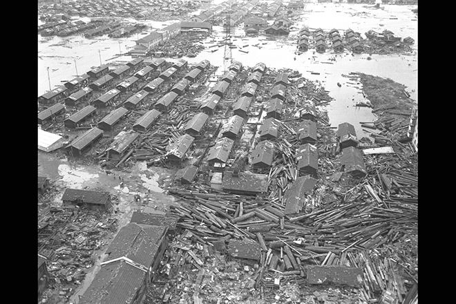 Homes in Nagoya’s Minami Ward are damaged by a storm surge during the 1959 Ise Bay Typhoon. (Asahi Shimbun file photo)

Nearly 70 percent of Japan’s coastal municipalities have yet to create legally required hazard maps that can guide residents to safety during the increasing threat of storm surges.
That means millions of people could find themselves trapped by flooding with no clear evacuation plan, according to an investigation by The Asahi Shimbun based on interviews with the land ministry.
Storm surge hazard maps are often described as a “compass” for protecting lives from typhoon-driven flooding.
The maps identify flood-prone areas, expected water depths and evacuation sites. Residents can use the maps to plan their evacuation routes in advance.
Storm surges occur when sea levels rise due to typhoons or low-pressure systems, potentially causing seawater to breach coastal defenses and flood nearby areas.
The Flood Prevention Law requires 39 coastal prefectures to designate areas expected to be flooded during exceptionally large typhoons. The 705 municipalities within these danger zones are required to create storm surge hazard maps.
However, as of June this year, the ministry said only 230 municipalities, or 32.6 of the total, had completed the hazard maps. They were located primarily in Tokyo, Aichi, Osaka and Fukuoka prefectures.
The 1959 Ise Bay Typhoon resulted in storm surges that killed or left missing more than 5,000 people in Aichi and Mie prefectures.
The storm surge caused by Hurricane Katrina in the United States in 2005 claimed more than 1,800 lives.
With climate change leading to more extreme weathers events, the risk of storm surges is expected to grow.
One major reason for the low completion rate of hazard maps in Japan is the slow progress in designating flood zones at the local level.
The ministry has instructed local governments to complete these designations by March 2026.
As of August this year, only 14 of the 39 coastal prefectures—including Kanagawa, Osaka and Fukuoka—had completed the process.
Four prefectures, including Hokkaido and Tokyo, had partially designated such areas, while the remaining 21 had not made any designations.
Without these designated flood zones, the coastal municipalities cannot proceed with the creation of hazard maps.
To identify flood-prone areas, local governments must simulate multiple scenarios involving typhoon paths.
Ten of the 25 prefectures that had not completed designations said they required more time to complete the simulations.
They cited budget constraints, staffing shortages, and the need for advanced technical expertise as contributing factors to the delays.


A peek through the music industry’s curtain at the producers who harnessed social media to help their idols go global.

A series based on diplomatic documents declassified by Japan’s Foreign Ministry

Here is a collection of first-hand accounts by “hibakusha” atomic bomb survivors.

Cooking experts, chefs and others involved in the field of food introduce their special recipes intertwined with their paths in life.

A series about Japanese-Americans and their memories of World War II


